Raceinfo

The central area of Nilsiä is characterized by flat terrain and relatively sparse rural development. The core of the competition area consists of the surroundings of school and shopping centers, which provide suitable route choice legs for a sprint event. In this competition, participants have the opportunity to do a short, intense effort to get their bodies ready for the demanding races later in the week.
One important note for competitors is that Nilsiäntie, the road that runs through the area, will remain open to vehicle traffic during the event. Crossing the road is only allowed at pedestrian crossings marked on the map (course marshals will monitor the crossings).
In planning the courses, we aimed to create routes appropriate for each competition class within the constraints of the terrain. For the main classes, we deliberately designed relatively long courses, while for children, considering the long week ahead, we opted for more moderate efforts.
Welcome to Nilsiä and enjoy your orienteering!
Erkki Saarijärvi, Head of the Course Setter Team
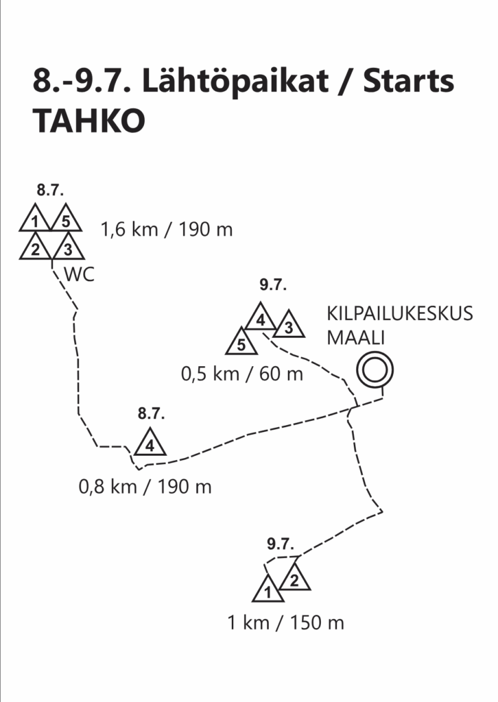
The second stage of the WOC Tour takes place in the terrain of Tahkovuori, Nilsiä. The area features significant elevation differences, so the start has been placed at the top of the hill, 200 meters higher than the finish. Terrain runnability varies, and at this time of year, undergrowth can slow progress in some areas.
Since the 2019 Fin5 Orienteering Week, new terrain has become available as former snow dumping areas have been partially restored. However, there is still a considerable amount of fallen trees in the forest, so green hatching on the map should be taken into account when making route choices.
The courses are designed in the spirit of long-distance orienteering, meaning there are also some long legs to challenge competitors. The total climb is fairly substantial, as we’ve made the most of the best parts of the terrain. The stairs in the Mäkiautio ravine are strictly out of bounds. Other areas are also off-limits due to nature conservation reasons – they are taped off in the terrain and will be monitored. There are water stations and first aid points in the forest.
The children’s courses (Start 4) also begin at the top of the hill, so there will be some steep downhill sections. The slopes contain grass and rocks, so a bit of caution is advised.
I wish all participants “sharp minds and swift feet” – that’s the key to your best performance.
Ossi Lakkala, Course Setter
The third stage of the WOC Tour takes place in the terrain of Tahkovuori, Nilsiä. There’s little need to describe the terrain: everyone can see the slopes, and many may remember them from the 2019 Fin5 event. Back then, the forest was plagued by storm-felled trees. That issue still exists to some extent, although the city has cleared parts of the forest, giving us access to some new orienteering terrain. The most difficult areas are marked on the map and should be considered when making route choices.
Since the long-distance race is held the day before in the same Tahko terrain – with a fair amount of climbing – the starts for Middle Distance (Starts 1 and 2) have been placed at the top of the slopes to keep total climb reasonable. Please allow enough time to reach the start locations. The final part of the courses descends toward the finish. Be cautious of loose stones hidden under vegetation on the slopes.
Starts 3 and 4 are located much lower on the hillside, so the total climb is comparable to – or even less than – that of a “normal” competition. As a result, winning times may be faster than expected, but that just gives everyone more time to head to Kuopio and cheer on the World Championship middle distance competitors!
The start triangle is shown on the competition maps only for Start 2. For the other starts, it has been omitted for clarity, as the control point (K-point) is located very close to the start triangle. The marked route from the start to the K-point is also hidden on the maps, but it is clearly marked in the terrain, as is the route from the last control to the finish.
A reminder to all: the wooden stairs built along hiking trails are strictly out of bounds during the competition. Orienteering shoes with metal studs can cause significant damage to them.
The competition map was prepared by Janne Weckman and Timo Joensuu. The latest updates reflecting recent construction changes were made this summer.
Wishing everyone a successful orienteering week
Raimo Antikainen & Hanna Väätäinen, Course Setters
Lassi Väänänen (Iisalmen Visa), Event Controller
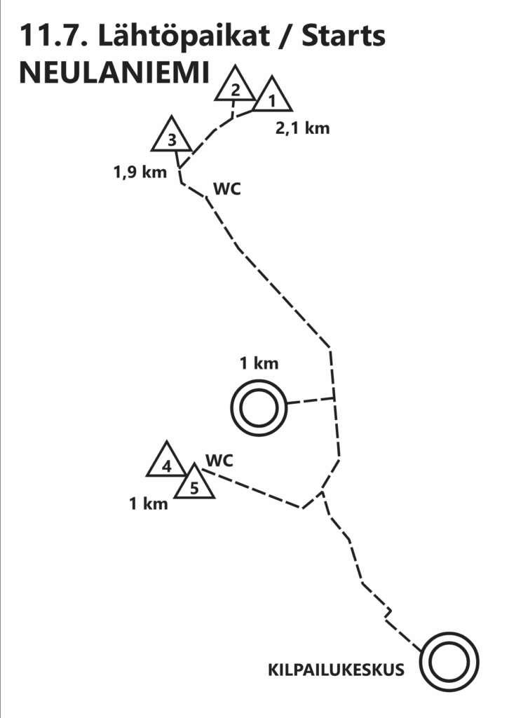
The runnability of the Neulaniemi terrain is variable. Ski track bases, a road along the western edge, and numerous paths help with movement. However, the condition of the paths varies greatly. Early in the open classes’ courses, there are challenging rocky trails that should be approached with caution. Moss-covered boulder fields and hummocky ground also slow progress.
The terrain is characterized by abundant rocky areas and numerous fallen trees. There is certainly enough elevation change, though the slopes are less steep than those at Tahko. Visibility varies: there are open pine forests and spruce stands, but also dense spruce thickets.
All competitors except children will face a climb of at least 60 meters during the final kilometer before the finish. Due to the location of the finish, all courses follow a ski track base for the last few hundred meters before branching off to the final controls. These controls are close together, so stay alert right to the end.
The controls are generally not technically difficult. Most are located on boulders, but I’ve tried to avoid placing them on isolated rocks in otherwise featureless areas – there are usually nearby features to aid navigation. My advice to competitors can be summed up in three points:
- Watch your step to avoid holes hidden under moss.
- Look ahead for fallen trees that may need to be bypassed.
- Keep track of your position on the map at all times.
Wishing you successful runs!
Mauno Korhonen, Course Setter
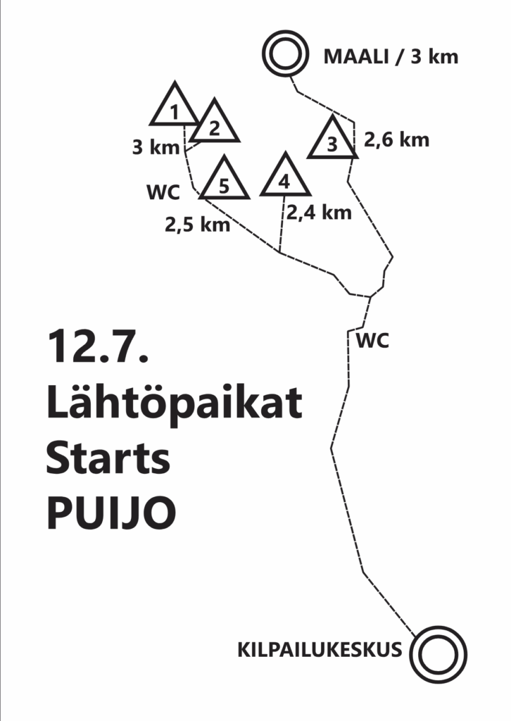
The fifth stage takes place on the slopes and summit of Puijonsarvi Hill. The competition area is only about 2.2 square kilometers in size, so controls are placed at nearly every possible feature. Be precise and always check the control code.
The hill has about 90 meters of elevation difference, so there will be a significant amount of climbing – especially from Starts 1, 2, and 5. Starts 3 and 4 involve considerably less climb, particularly on the shortest courses.
The terrain is part of Kuopio’s outdoor recreation area, so there are many paths – though not all of them are shown on the map, which helps maintain good map readability. The forest is mostly mature spruce and generally offers good runnability. Some areas have windthrow, and these are mapped similarly to the rocky areas on the slopes.
Undergrowth in the Puijonsarvi area is sparse even in July, so competitors can maintain a good pace – only the contour lines and some demanding slope controls may slow you down. Due to the small size of the area, some courses will cross the taped RR/TR (beginner) routes multiple times.
Markku Kotamäki, Course Setter
Maps to Starts